Completed: Design-Build Project 238275-7 (Map Section 6) – From State Road 429 to West of Longwood Markham Road
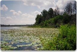
This design-build project built more than 6 miles of limited access toll road largely along the existing State Road (S.R.) 46 corridor from S.R. 429 to just west of Longwood-Markham Road. The project included a non-tolled, service road for local travel, new bridges over the Wekiva River, as well as several wildlife bridges to allow animals to pass safely between the Seminole State Forest and Rock Springs Run State Reserve.
A multi-use trail is included along this section. Work included bridges, connector roads between remaining sections of County Road (C.R. 46A) and S.R. 46, roadway widening, medians and turn lanes, drainage, lighting, sign and pavement markings, utilities and other roadway features.
Project Schedule:
Construction Start: October 18, 2017
Parkway Lanes Open: May 16, 2022
Construction Completion: Fall 2022
WEKIVA PARKWAY PROJECT SECTION 6 MAP
Section 6 Revised 100% Roadway Plans Segment A June 2018
Section 6 Revised 100% Roadway Plans Segment B June 2018
Section 6 Revised 100% Roadway Plans Segment C June 2018
Section 6 Revised 100% Sign and Pavement Marking Plans Segment A June 2018
Section 6 Revised 100% Sign and Pavement Marking Plans Segments B & C June 2018
Section 6 Landscape Plans June 2018
Section 6 Landscape Opportunity Plans June 2018
Section 6 FDOT Signal Warrant Study – S.R. 429 at S.R. 46 (Sorrento)
Section 6 Project Fact Sheet, Updated Sept. 14, 2017
Section 6 NPS Section 7(a) Analysis and Determination February 2015
Section 6 NPS Concurrence Letter March 2015
Appendix A - Pile Removal Memorandum
Appendix B - Noise Study Memorandum
Appendix C - 2 vs 3 bridge comparison
Appendix D - Meeting minutes from NPS Discussions
Appendix E - Shade Study
Appendix F - Wekiva Parkway NPS Drainage criteria
Appendix G - Migratory Bird Correspondence
Appendix H - PD&E Concept Level Studies
Appendix I - Comprehensive Management Plan
Appendix J - Wekiva River Bridge BHR
Appendix K - Charette Summary Report Reduced
Section 6 Geotechnical Report Pt I
Section 6 Geotechnical Report Pt II
Section 6 Geotechincal Report WL1
Section 6 Geotechnical Report WL2
Section 6 Soil Survey
Section 6 Geotechnical Wall Report
Section 6 Final Pond Siting Report_Part I_August 2014
Section 6 Final Pond Siting Report Part II August 2014
Section 6 Final Pond Siting Report Part III August 2014
Wekiva River Video Float Through
Wekiva River Bridge Charette Summary_March 2014
Wekiva River Bridge Charette No. 1_Dec. 11, 2013
Wekiva River Bridge Charette No. 2_Jan. 28, 2014
All FDOT Sections
Want to know more about how FDOT handles right-of-way matters? Click on the documents below:
Check out the FDOT Aesthetics Guidelines by clicking here.

 Facebook
 Twitter
 YouTube